After an agreement was reached between North and South Korea to establish a buffer or peace zone in the West Sea, old arguments and disagreements concerning the Northern Limit Line and the North Korean claimed maritime boundary between North and South Korea are being raised. Conservative critics say that South Korean military negotiators have not "respected" the Northern Limit Line and yielded maritime interests to North Korea in the agreement which emerged as part of the Panmunjum and Pyongyang summits. The origins of the Northern Limit Line and the dispute associated with it after the Korean Armistice, are obscure. The reader is referred to the Wikipedia summary of the history and contentions of the parties to the various claims, disputes, understandings and incidents that have occurred over the years as recently as recently as 2010.
https://en.wikipedia.org/wiki/Northern_Limit_Line
Civil defense drills are still a part of life on the islands in the South Korean zone. Such a drill for school age children took place in Bekryeong Island during the time of the summit. The movement of tourists and civilians on the islands are subject to security restrictions because of their close proximity to North Korea. There remains an underlying disagreement between the two Korean states about where the border line is in the maritime zone. By declaring a demilitarized maritime area, the intention is that chances for military confrontation and war will be minimized.
The essence of the new military agreement apart from the designation of the zone in the graphic below is that military and naval exercises and maneuvers are prohibited in the zone. Firing of any kind is prohibited whether from shore batteries on islands or naval firing exercises. It is difficult to ascertain further details without an authoritative copy of the agreement.

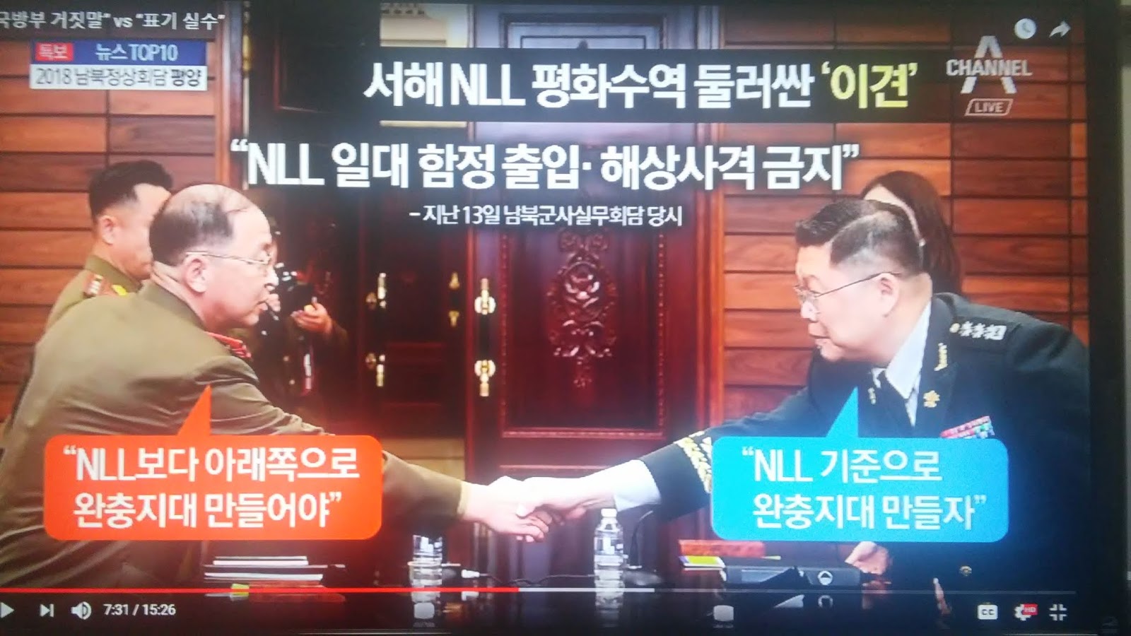
The red line is the Northern claim to the maritime boundary. The South's claim is the Northern Limit Line in blue. The restriction of naval activities in the region papers over the dispute over between the two states about where the boundary should be officially. So it represents a compromise by the South. Using the NLL as the base for measurement (on a north south line only) the North gives up 50 km of military space, and the South 85 km. Using the North's West Sea border line claim, the North gives up 65 km of maritime space for military activities, and the South 70 km. This is the Channel A Top Ten News presentation on the issue which could hardly considered to be unbiased as it was very critical to the Moon administration and taking the conservative view, that South Korean military representatives had capitulated to North Korean demands, which seems somewhat improbable. One radio critic claimed the South was intimidated by North Korean nuclear capability.
The Channel A broadcast purported that valuable exercise opportunities, and readiness drills were adversely affected on the South's part. Further, that the military agreement left unclear the status of the NLL, and whether Cho island at the northern extreme of the restricted area was included or not in the agreement giving the North a military advantage in the protection of military approaches to Pyongyang. It was also contended that Kyongkido and Seoul were threatened by the agreements restrictions on military activities in the zone.
South Korean Defense Ministry sources say that military procedures for responding to any provocations in the designated Maritime buffer zones will be the same and that security measures will be effective.
Update 9.29

JTBC News has entered the discussion concerning the military agreement providing for the buffer zone in the West Sea on behalf of the current South Korean administration and Ministry of National Defense. According to their report, the buffer zone restrictions on military activities in the zone do not affect the NLL as the boundary of the respective states' maritime territory at all. Additionally, as shown by the chart above, the effect of restrictions on training and operations is far greater on the much more extensive shoreline of North Korea within the zone. The restriction on the use of artillery in the buffer zone is proportionately much greater on North Korea, which has many more artillery assets deployed in the coastal region. The effect on naval maneuver in the zone is felt to be minimal because such exercises can readily take place outside the zone.
No comments:
Post a Comment